Monday 24 December 2018

Sonmarg, Kashmir

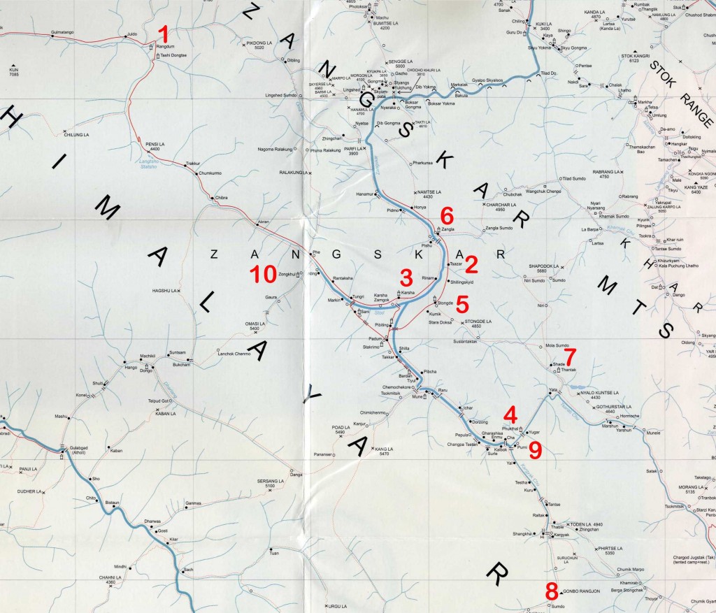
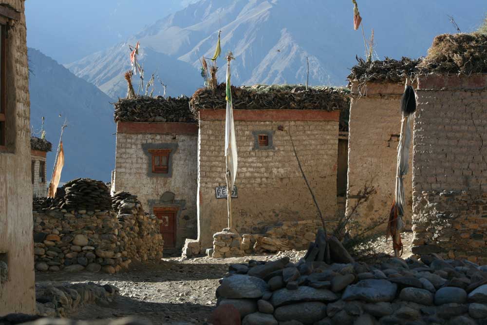
When you drive from Srinagar to Leh, Sonmarg is the last stop of Kashmir District. From here starts the territory of Ladakh. Situated at an altitude of 2743 m above sea level, Sonmarg is absolutely true to its name, which means 'Meadow of Gold'. The moment you enter Sonmarg, the first thing that you will notice will be the snow-covered mountain that forms the backdrop of the town. Covered with alpine trees from all sides, Sonmarg has few of the loveliest flower collection in J & K. In winters though, the town is covered with snow giving it an altogether different charm of white. The town has become famous for the many excursion option that it offers, mainly short walks and trek routes to nearby stunning areas. The most famous trek is definitely the one that takes you to Amarnath caves. In fact Baltal which is just besides Sonmarg is used asa base camp for starting the holy Amarnath yatra. 

Location: 81-km from Srinagar, Kashmir Region, J&K 

How to spend time/Attractions: Trekking, Alpine Skiing, Angling, Long walks, White water rafting, Sledging, Horse riding, Photography, Sightseeing, etc. 

Best Time to Visit:
 May To September, November to February 

Places to Visit: 

Thajiwas Glaciers: Thajiwas is one of the most popular short walks from Sonamarg and a major attraction during the summer months. It is 4-km route to Thajiwas, a small valley at the foot of the Sonamarg glacier. A path leads up to the Shakhdar hill, overlooking the glacier from the northeast. It is dangerous to climb the steep slope leading up to the glacier. The miniature plateaus, snowfields, pines and islets add to the charm of Thajiwas. Thajiwas is a short and interesting walk from Sonamarg in Jammu Kashmir. During daytime one can take the 3-mile horseback ride west, then south, to the Thajiwas glacier.


BALTAL CAMPING BASE: 
This beautiful meadow is right at the foot of the Zoji La pass and thus is the final place in Kashmir. The river from the foot of the Amarnath glacier meets the Indus near Baltal. It stands at a height of 2,743m and during the Amarnath pilgrimage there are tents set up here. It is possible to walk to the Amarnath cave, more usually approached from Pahalgam, in one day. Check about conditions before departing, though. The weather can be treacherous and at other times melting snow and ice make the route very dangerous. There's now a jeep road most of the way to the cave. The turn off to Baltal is at 94-km on the Leh road, and then it's 3-km or so downhill.

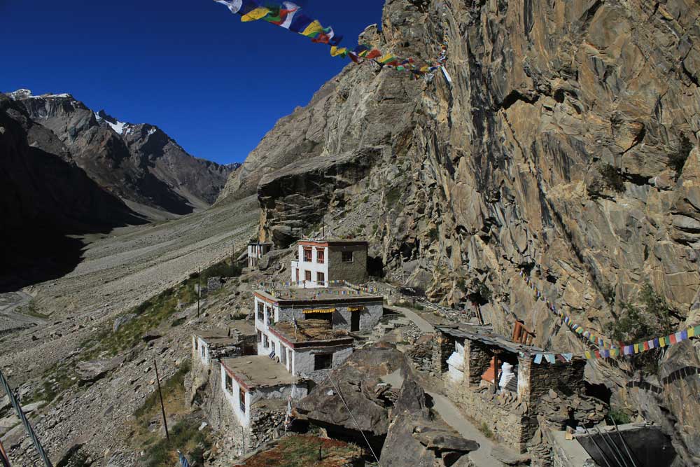
Zajibal Pass: Zajibal pass is also known as gateway to Ladakh, Jammu and Kashmir. Here you can have a clear view of Gangabal Lake 2,000 feet below, 16,872-foot Haramukh above. For this alpine trek over the Nichinai to Gangabal Lake and down the Wangat valley, you will need about seven days. This is the most dangerous pass in the region.
Nilagrad: Amongst the many spots worth visiting is the Nilagrad. Nilagrad is a colony of the Baltics where a small stream meets the Mountain River Sindh. It is 6 kms. Away from Sonmarg. The water of the river is reddish in colour. The Baltics believe that the reddish color of water is due to its curative power of many diseases. So, inhabitants of the colony visit this river every Sunday.
Krishnasar Lake: is located near the famous hill station of Sonmarg in Srinagar District. It lies at an altitude of 3,801m, and is popular for trout fishing. The lake with its scenic and peaceful atmosphere is perfect for holidays. This picturesque lake can be accessed through the Nichinai Pass which is at an altitude of 4084 m. nearby lies another lake, called Bisansar Lake noted for its natural beauty. Best time to visit the lake and its surroundings is during mild summer from April to June.

Patni Top,Jammu

Patni top is a hill station based in udampur district of Jammu and Kashmir, India.
visiter can easily reach there by public transportation and private vehicle. udampur is the nearest city from patni top
and from udampur public busses are available at 70 to 80rs per person.
patni top is cool place for family vacations. at very cheap price. visiters can book hotels from 700rs/per night to 2000/per night for double bed.
best time to visit patni top is from October to March,it you want to enjoy snow.


How to Reach: Easily get buses from Jammu, Katra and Udhampur. 

Best time to Visit:
 May-June and September-October 
How to spend time/Attractions: Golf, Trekking, Skiing, Paragliding, Long walks, Horse riding, Day Picnic, Photography, Sightseeing, etc. 

Places to visit:
 
Batote:-125 Kms. from Jammu on the way to Patnitop, Situated at an altitude of 1560 metres on the Jammu-Srinagar national highway, this resort straddles the forested slopes of the Patnitop mountain range, overlooking the spectacular lie of the Chenab gorge

Sanasar :
 
Sanasar is 18kms from Patnitop (advised to carry Picnic lunch). Play Golf / have Pony or Joy ride in a Para Glider (only for age groups 15yrs to 45yrs and if weather permitting) - in winters enjoy Snow Skiing at Patni Top / Natha Top.
Sudh Mahadev:-This holy spot near Patnitop is situated at an altitude of 1225 mtrs and about 120 kms from Jammu. Pilgrims visit the shrine on the full moon night of 'sawan' (July-August) to worship the 'Trishul' (trident) and a mace, which are said to have belonged, to Bheem, one of the five legendary Pandava brothers. The Devak stream originates at Sudh Mahadev and disappears among the rocks a few kilometres downstream.

Gauri Kund : 
Some distance short of Sudh Mahadev is the legendary spring where the Goddess Parvati used to have bath before commencing her daily prayers at Sudh Mahadev. This spring came to be named after her as 'Gauri Kund'.
Mantalai:-Situated a few kilometers further away from Sudh Mahadev, Mantalai is surrounded by lush deodar forests at an altitude of 2000 m. The place is associated with the legend of the marriage of Lord Shiva with the Goddess Parvati.
Mansar Lake:-90 kms from Patnitop. A beautiful lake fringed by forest-covered hills. Boating facilities are available on the spot. Every year around Baisakhi, a food and crafts festival is organised here by J&K Tourism


Wednesday 12 December 2018

Zanskar

location map of Zanskar
Zanskar  is a subdistrict or tehsil of the Kargil district, which lies in the eastern half of the Indian state of Jammu and Kashmir. The administrative centre is Padum. Zanskar, together with the neighbouring region of Ladakh, was briefly a part of the kingdom of Guge in Western Tibet.
The Zanskar Range is a mountain range in the Indian state of Jammu and Kashmir that separates Zanskar from Ladakh. Geologically, the Zanskar Range is part of the Tethys Himalaya, an approximately 100-km-wide synclinorium formed by strongly folded and imbricated, weakly metamorphosed sedimentary series. The average height of the Zanskar Range is about 6,000 m (19,700 ft). Its eastern part is known as Rupshu.
It also separates Kinnaur District from Spiti in Himachal Pradesh. The highest peaks of Himachal are in the Zanskar Range.

Best Time to Visit

Owing to the altitudes the Zanskar valley is accessible only during the summer months. The winter months are too harsh for travel in Zanskar. It is noteworthy that in the winter months the water of the River Zanskar freezes and becomes the Chador road.

How to Reach

BY ROAD - It is noteworthy that the road that links Zanskar with Kargil is open from mid July to early November. Buses. Jeeps, gypsies and taxis are easily available for transport to Zanskar from Kargil. Kargil is approximately 235 km away from Zanskar. During the months of June and July you may trek into Zanskar from Panikhar or Parkachik onwards.

The hill resort of Zanskar is one of the isolated and scantly inhabited Himalayan Valleys. Zanskar is wrapped in snow-covered peaks and boats of two small alpine lakes. But there is nothing comparable to the wonderful view of the "Drang-Drung" glacier.
Panikhar is an important place in the Zanskar Valley that is the border of the Suru Valley. At Panikhar the fort of Zorawar Singh is a major tourist attraction
Then there is the Penzella Pass that divides the Zanskar valley with the Suru Valley. Besides being the excellent camping site the Penzella Pass is a vintage point offering excellent views of the majestic mountains and the captivating countryside.
Karsha is a human settlement with basic facilities. The Gelugpa monastery at Karsha is a must visit to know the importance of the religion in the lives of the inhabitants of Zanskar. The mural art displayed at Labrang is other must check out in Zanskar
On the isolated mountains there are several places associated with the Tibetan Buddhists that are worth exploring
The adventure seekers may try river rafting from Serchu to Nyimu via Padam. Trekking is possible to Panikhar or Rangdum over the Pentse La, into the Zanskar Valley from Lamayuru, Leh or Darcha, from Padum to the Markha valley et al. The climatic conditions need to be kept in mind choosing the trek.

Kalyans Top 10 places in Zanskar

zanskar-map
Overview of Kalyan’s favorite places. (Map by Sonam Tsetan & Henk Thoma)

1. Rangdum

rangdum
Monastery Rangdum
Rangdum is surrounded by mountains and cliffs in all possible shades and colors. Most prominent, however, are the twin mountains Nun & Kun – both 7000s. For me, the mountain views make Rangdum a unique place in the world. In addition, the marshes of Rangdum attract every summer countless birds that are a pleasure to observe and admire. More personally, I associate Rangdum with many happy memories. From here I started the first trek of my life: one April, when the road to Zanskar was still blocked by the snow, I walked all the way to Zanskar over the Pensi La. Tip: Be sure to witness the sunset here! It is really unbelievable.

2. Tsazar

TsazarWinter
Kalyan’s village during winter
This is the village in which I was born and where I spent my early childhood. For me that’s reason enough to include this typical zanskari village in this list.

3. Karsha

Karsha (c) Tashi Wangail
View from Karsha monastery
Karsha is the village with the largest monastery of Zanskar. I love to join the morning Puja of the monks and watch the young novices, who might one day become important spiritual teachers of the country. The view of the central valley, from the monastery, is absolutely breathtaking

4. Phuktal

zanskarphuktal
Phuktal is the most isolated monastery in Zanskar. I have often visited it, especially when I was hiking on the Great Zanskar Trek. To get there is always one of the biggest highlights in a trip. The sight and the architecture are truly breathtaking. The place always makes me think of a giant beehive.

5. Stongde

stongde
Stongde is the closest monastery to my village, which is why I have also spent a lot of time there. I appreciate the stillness of this place, in addition of course to the magnificent view of the mountains and the village at the foot of the monastery.

6. Zangla

Zangla is one of the largest villages of Zanskar. I love to walk through the town to watch the old people with their prayer wheels, sitting under the warm sun, and listen to them while murmur their prayers. Zangla is the village of my grandmother, and many of my relatives live here.

7. Shade

shade
In Shade, people still live extremely isolated from the rest of the world
Shade is one of the most remote villages in the whole of Zanskar and Ladakh, if not the world. Even the natives, walking with fast feet over known trails, need at least two days to get here. I was there recently and it was very impressive to see how well here the interaction between man, animal and nature still works.


8. Gonbo Rangjon

gomborangjung
Gonbo Rangjon is a spiritually important mountain for the Zanskari
Gonbo Rangjon, a sacred mountain, is located along the trekking route to Darcha, before Shingo La. I call the region around Gonbo Rangjon “the summer paradise of Zanskar”. It is a dream to wander here and admire the flowers that grow in the mountain pastures.

9. Purne

purne
This beautiful little village is home to just two families. Purne is my favorite camping site, whenever I’m on a trekking tour. The first really nice and homelike Resthouse/Homestay/Hostal with clean rooms and good local food is also located in Purne.

10. Dzongkhul

dzongkhul
Here is a meditation cave of Naropa and many other great lamas were here. From Dzongkhul also starts the route through the Paldar Valley. I’ve always liked the stories from travelers who came through this valley: the Paldar Valley connects Zanskar with Jammu and until today, people from both sides use it to meet, share and commerce with each other. Also Zorawar Singh, who took Ladakh from the hands of the Maharaja of Jammu, started his campaign here, leading ultimately to the loss of independence of the country

Tuesday 11 December 2018

Darjeeling,West bengal

Darjeeling is a town in India's West Bengal state, in the Himalayan foothills. Once a summer resort for the British Raj elite, it remains the terminus of the narrow-gauge Darjeeling Himalayan Railway, or “Toy Train,” completed in 1881. It's famed for the distinctive black tea grown on plantations that dot its surrounding slopes. Its backdrop is Mt. Kanchenjunga, among the world’s highest peaks.

  1. Padmaja Naidu Himalayan Zoological Park

    Zoological park with endangered species
    68-acre zoo featuring endangered Himalayan animals such as red pandas & snow leopards.
  2. Ghum Monastery

    Tibetan Buddhist monastery built in 1875
    Elevated 19th-century Tibetan Buddhist monastery featuring a 15-ft. Buddha statue & sacred texts.
  3. Peace Pagoda, Darjeeling

    Buddhist temple in a tranquil locale
    Serene Buddhist temple with a domed roof, gilded statues, ornate carvings & valley views.
  4. Tenzing Rock

    Destination for rock-climbing practice
    One of a pair of large natural rocks used by people to practice rock-climbing, including beginners.
  5. Japanese Buddhist Temple

    Japanese temple & pagoda with views
    Traditional Japanese-style Buddhist temple & multi-level pagoda offering commanding mountain views.
  6. Happy Valley Tea Estate

    Garden
    Happy Valley Tea Estate is a tea garden in Darjeeling district in the Indian state of West Bengal. Established in 1854, it is Darjeeling's second oldest tea estate. Spread over 177 hectares,
  7. Tiger Hill, Darjeeling

    Staple for mountain & sunrise views
    Visitors come to watch the sunrise on this hill with dramatic views of Mt. Everest & Kangchenjunga.
  8. Bengal Natural History Museum

    Natural history museum with bugs & moths
    Natural history museum with dioramas, taxidermy & lepidopteral & entomological specimens.
  9. Bhutia Busty Monastery

    Tibetan-style Buddhist monastery
    Quaint, Tibetan-style Buddhist monastery featuring an ornate front gate & vibrant wall murals.
  10. Buddhist Monastery

    Vibrant temple with hillside views
    Peaceful Buddhist monastery known for its vibrant, multi-level facade & dramatic hilltop views.
  11. Dali Monastery

    Elaborate Buddhist monastery with art
    Ornate, colorful Buddhist monastery with art & sculpture, including a giant Buddha figure.
  12. Jhandi Dara Sunrise Point

    Lookout area known for sunrises
    Scenic overlook popular for its sunrise views across to the snowcapped peaks of Kangchenjunga.
  13. Lebong Race Course

  14. Mahakal Mandir

    Hilltop Hindu temple with a sacred cave
    Hindu temple on Observatory Hill featuring a sacred cave & a variety of colorful flags.
  15. Darjeeling Mall

  16. Ava Art Gallery

    Museum with paintings by Ava Devi
    Established in 1965, this colorful museum features oil, water & thread paintings by Ava Devi.
  17. Darjeeling Rangeet Valley Passenger Ropeway

    Historic cablecar with tea-garden views
    Opened in 1968, the country's first cablecar system offers panoramic views of historic tea gardens.
  18. Senchal Lake

    Lake and wildlife
    Senchal lake, located 10 km to the south-east of Darjeeling, is the main reservoir of potable water for the town of Darjeeling, India. The lake is located at an altitude of 8,160 ft atop a hill
  19. Shrubbery Nightingale Park

    Tranquil, landscaped park & garden
    Peaceful green space with landscaped gardens, sheltered benches & a large state of Lord Shiva.
  20. Gombu Rock

    Mountaineering
  21. Himalayan Tibet Museum

    Exhibits on Tibetan history & culture
    Tibetan history & culture museum with artifacts & exhibits, including a 3-D model of the Himalayas.
  22. Darjeeling Himalayan Railway

    Famed steam train from the late 1800s
    Mountain railway with steam locomotives, winding through scenic terrain since the late 1800s.
  23. Mirik

    Lakes, gardens, orchards, and monasteries
    Mirik is a tourist spot located in the hills of Darjeeling district in West Bengal, India. It is the headquarters of Mirik subdivision. The name Mirik comes from the Lepcha words Mir-Yok meaning
  24. Mall Road

    Shopping
  25. Lower Fagu Tea Estate

    Lower Fagu is a small tea garden located in the Kalimpong district of West Bengal, India. The area falls under the 43rd constituency of Gorkhaland Territorial Administration. It is situated on
  26. Kanchenjunga View Point behind Mahakal Mandir


  27. Ghoom Monastery (Samten Choeling)

    Monastery
  28. Deshbandhu Museum

  29. Tiger Hill Sunrise Observatory

    Sunrise vista with a Himalayan backdrop
    Popular hilltop attraction offering sweeping sunrise views against the Himalayan Mountains.
  30. HMI MUSEUM

  31. Roy villa

    Historic mansion with a museum & classes
    Cultural landmark with a European-castle feel, now with a small museum & educational programs.
  32. Hayden Hall

  33. Barbatia Rock Garden

    Tranquil park with waterfalls & rocks
    Photography is popular at this scenic, hilly hangout next to waterfalls with flowers & rocks.
  34. Observatory Hill View Point

  35. Famous Temple

  36. Tea Garden View

  37. Batasia Eco Garden

    Garden
  38. Ropeway Darjiling

  39. Darjeeling Clock Tower

  40. Ghoom Railway Museum

  41. Buddhist Temple


  42. Dheerdham Shivalay


  43. St. Andrews Church

  44. Sherpa Monastery

  45. Gangamaya Park, Darjeeling, WB

  46. Hill Cart Road

  47. Lamahatta Park

    Park
  48. Kitam Bird Sanctuary

    Wildlife preserve with a tranquil vibe
    This peaceful, riverside nature conservation area is a habitat for peafowl & other species.
  49. Pandam Tea Garden


History

Bringing in the Darjeeling tea harvest, circa 1890.
the King of Sikkim in Darjeeling about 1900
The history of Darjeeling is intertwined with that of Nepal, Sikkim, British India, and Bhutan. Until the early 19th century, the hilly area around Darjeeling was controlled by the Kingdom of Sikkim with the settlement consisting of a few villages of the Lepcha and Kirati people. The Chogyal of Sikkim had been engaged in unsuccessful warfare against the Gorkhas of Nepal.
From 1780, the Gorkhas made several attempts to capture the entire region of Darjeeling. By the beginning of the 19th century, they had overrun Sikkim as far eastward as the Teesta River and had conquered and annexed the Terai and the entire area now belonged to Nepal.[9] In the meantime, the British were engaged in preventing the Gorkhas from over-running the whole of the northern frontier. The Anglo-Gorkha war broke out in 1814, which resulted in the defeat of the Gorkhas and subsequently led to the signing of the Sugauli Treaty in 1816. According to the treaty, Nepal had to cede all those territories which the Gorkhas had annexed from the Chogyal of Sikkim to the British East India Company (i.e. the area between Mechi River and Teesta River). Later in 1817, through the Treaty of Titalia, the British East India Company reinstated the Chogyal of Sikkim, restored all the tracts of land between the River Mechi and the River Teesta to the Chogyal of Sikkim and guaranteed his sovereignty.[10]
In 1828, a delegation of the British East India Company (BEIC) officials on its way to the Nepal-Sikkim border stayed in Darjeeling and decided that the region was a suitable site for a sanatorium for British soldiers. The company negotiated a lease of the area west of the Mahananda Riverfrom the Chogyal of Sikkim in 1835.[13] In 1849, the BEIC Superintendent Archibald Campbell and the explorer and botanist Joseph Dalton Hooker were imprisoned in the region by the Sikkim Chogyal. The BEIC sent a force to free them. Continued friction between the BEIC and the Sikkim authorities resulted in the annexation of 640 square miles (1,700 km2) of territory by the British in 1850. In 1864, the Bhutanese rulers and the British signed the Treaty of Sinchula that ceded the passes leading through the hills and Kalimpong to the British. Further discord between Sikkim and the British resulted in a war, culminating in the signing of a treaty and the annexation by the British of the area east of the Teesta River in 1865. By 1866, Darjeeling district had assumed its current shape and size, covering an area of 1,234 square miles (3,200 km2).
A view of the Darjeeling War Memorial, located at the Batasia Loopof the Darjeeling Himalayan Railway. Kangchenjunga is visible in the background.
During the British Raj, Darjeeling's temperate climate led to its development as a hill station for British residents seeking to escape the summer heat of the plains. The development of Darjeeling as a sanatorium and health resort proceeded briskly. Arthur Campbell, a surgeon with the Company, and Lieutenant Robert Napier were responsible for establishing a hill station there. Campbell's efforts to develop the station, attract immigrants to cultivate the slopes and stimulate trade resulted in a hundredfold increase in the population of Darjeeling between 1835 and 1849. The first road connecting the town with the plains was constructed between 1839 and 1842. In 1848, a military depot was set up for British soldiers, and the town became a municipality in 1850. Commercial cultivation of tea in the district began in 1856, and induced a number of British planters to settle there. Darjeeling became the formal summer capital of the Bengal Presidency after 1864. Scottish missionaries undertook the construction of schools and welfare centres for the British residents, laying the foundation for Darjeeling's notability as a centre of education. The opening of the Darjeeling Himalayan Railway in 1881 further hastened the development of the region. In 1899, Darjeeling was rocked by major landslides that caused severe damage to the town and the native population.
Map of the station and its environs, ca 1914
Under the British Raj, the Darjeeling area was initially a "Non-Regulation District", a scheme of administration applicable to economically less advanced districts in the British India; acts and regulations of the British Raj did not automatically apply to the district in line with rest of the country. In 1919, the area was declared a "backward tract". During the Indian independence movement, the Non-cooperation movementspread through the tea estates of Darjeeling. There was also a failed assassination attempt by revolutionaries on Sir John Anderson, the Governor of Bengal in 1934. Subsequently, during the 1940s, Communist activists continued the nationalist movement against the British by mobilising the plantation workers and the peasants of the district.
A hillside with houses having tiled roofs.
Darjeeling view, 1880
Socio-economic problems of the region that had not been addressed during British Raj continued to linger and were reflected in a representation made to the Constituent Assembly of India in 1947, which highlighted the issues of regional autonomy and Nepali nationality in Darjeeling and adjacent areas. After the independence of India in 1947, Darjeeling was merged with the state of West Bengal. A separate district of Darjeeling was established consisting of the hill towns of Darjeeling, Kurseong, Kalimpong and some parts of the Terai region. While the hill population comprised mainly ethnic Nepalis, the plains harboured a large ethnic Bengali population who were refugees from the Partition of India. A cautious and non-receptive response by the West Bengal government to most demands of the ethnic Nepali population led to increased calls, in the 1950s and 1960s, for Darjeeling's autonomy and for the recognition of the Nepali language; the state government acceded to the latter demand in 1961.
The creation of a new state of Sikkim in 1975, along with the reluctance of the Government of India to recognise Nepali as an official language under the Constitution of India, brought the issue of a separate state of Gorkhaland to the forefront. Agitation for a separate state continued through the 1980s, included violent protests during the 1986–88 period. The agitation ceased only after an agreement between the government and the Gorkha National Liberation Front (GNLF), resulting in the establishment of an elected body in 1988 called the Darjeeling Gorkha Hill Council (DGHC), which received autonomy to govern the district. Though Darjeeling became peaceful, the issue of a separate state lingered, fuelled in part by the lack of comprehensive economic development in the region even after the formation of the DGHC.[27] New protests erupted in 2008–09, but both the Union and State governments rejected Gorkha Janmukti Morcha's (GJM) demand for a separate state. In July 2011, a pact was signed between GJM, the Government of West Bengal and the Government of India which includes the formation of a new autonomous, elected Gorkhaland Territorial Administration (GTA), a hill council endowed with more powers than its predecessor Darjeeling Gorkha Hill Council.

Geography

View of Kanchengjunga as seen from Darjeeling
Darjeeling is the main town of the Sadar subdivision and also the headquarters of the district. It is located at an elevation of 6,700 ft (2,000 m) in the Darjeeling Himalayan hill region on the Darjeeling-Jalapahar range that originates in the south from Ghum. The range is Y-shaped with the base resting at Katapahar and Jalapahar and two arms diverging north of the Observatory Hill. The north-eastern arm dips suddenly and ends in the Lebong spur, while the north-western arm passes through North Point and ends in the valley near Tukver Tea Estate. The hills are nestled within higher peaks and the snow-clad Himalayan ranges tower over the town in the distance. Kanchenjunga, the world's third-highest peak, 8,598 m (28,209 ft) high, is the most prominent mountain visible. On clear days Nepal's Mount Everest, 29,035 ft (8,850 m) high, can be seen.
The hills of Darjeeling are part of the Lesser Himalaya. The soil is chiefly composed of sandstone and conglomerate formations, which are the solidified and upheaved detritus of the great range of Himalaya. However, the soil is often poorly consolidated (the permeable sediments of the region do not retain water between rains) and is not considered suitable for agriculture. The area has steep slopes and loose topsoil, leading to frequent landslides during the monsoons. According to the Bureau of Indian Standards, the town falls under seismic zone-IV, (on a scale of I to V, in order of increasing proneness to earthquakes) near the convergent boundary of the Indian and the Eurasian tectonic plates and is subject to frequent earthquakes.

Tourism

Tourist inflow into Darjeeling had been affected by the political instability in the region, and agitations in the 1980s and 2000s hit the tourism industry hard. However, since 2012, Darjeeling has once again witnessed a steady inflow of both domestic and international tourists. Presently, around 50,000 foreign and 500,000 domestic tourists visit Darjeeling each year, and its repute as the "Queen of the Hills" remains unaltered. According to an India Today survey published on 23 December 2015, Darjeeling is the third most Googled travel destination among all the tourist destinations in India. Even though there are political instabilities in Darjeeling, its tourism rate is increasing year by year. Many visit this place for food specialities like momos, steamed stick rice, and mostly steamed foods are famous in this region. Many tourist visit this place for seeing the natural beauty of nature .

Transport

A train, hauled by a steam locomotive, running beside a road between two rows of buildings with a few people walking on the road.
The narrow gauge train often crisscrosses the street
Darjeeling "Toy Train"
Darjeeling can be reached by the 88 km (55 mi) long Darjeeling Himalayan Railway from New Jalpaiguri, or by National Highway 55, from Siliguri, 77 km (48 mi) away. The Darjeeling Himalayan Railway is a 600 mm (2 ft) narrow-gauge railway that was declared a World Heritage Siteby UNESCO in 1999 for being "an outstanding example of the influence of an innovative transportation system on the social and economic development of a multi-cultural region, which was to serve as a model for similar developments in many parts of the world", becoming only the second railway in the world to have this honour. Bus services and hired vehicles connect Darjeeling with Siliguri and Darjeeling has road connections with Bagdogra, Gangtok and Kathmandu and the neighbouring towns of Kurseong and Kalimpong. However, road and railway communications often get disrupted in the monsoons because of landslides. The nearest airport is Bagdogra Airport, located 90 km (56 mi) from Darjeeling.[61] Within the town, people usually traverse by walking. Residents also use two-wheelers and hired taxis for travelling short distances. The Darjeeling Ropeway, functional since 1968, was closed in 2003 after an accident killed four tourists. It reopened in February 2012.